 Catálogo de datos del IEO
Keyword
sidescan sonars
10 record(s)
Type of resources
Categories
Topics
INSPIRE themes
Keywords
Contact for the resource
Provided by
Years
Formats
Status
-
Studying the role played by formation of deep water in the chemical composition and budgets of matter in the Mediterranean. Understanding the relationships between the way plankton food webs are organized and the hydrodynamic structures. The related project is MISTRALS - MerMEX.
-
The main objective of the MOOSE-GE cruises is to observe the annual evolution of the Northwestern Mediterranean Sea in the context of the climate change and anthropogenic pressure in order to be able to detect and identify long-term environmental trend and anomalies of the marine ecosystem. The annual cruise focuses on moorings maintenance and hydrology, biogeochemistry and biology monitoring of the Northwestern Mediterranean basin. It aims to follow variability of water masses properties (LIW and WMDW) and biogeochemical and biological content related to these water masses.
-
<p>Studying eddies related to water circulation in the Gulf of Lion. The LOPB and LOMIC labs will implement a technique never used before for coastal systems, i.e. tracking of a water mass using the chemically inert compound sulphur hexafluoride (SF6). After injecting the tracer from aboard RV Suroît, the substance's dissemination will be estimated thanks to real-time measurements performed on board. To monitor the eddy structure, RV Suroît will be accompanied by RV Tethys II. Several innovative devices or systems will be deployed simultaneously (measuring currents using Doppler acoustic profiler (with the moorings already in the zone since 2009 and the 2 vessels' shipboard current meters); Measuring surface currents using an array of HF radars installed onshore; several satellite-monitored drifting buoys, including a CARIOCA buoy which will continuously log the physical parameters and CO2 trends near the surface; autonomous underwater gliders fitted with various biogeochemical sensors; real-time satellite observation of surface temperature and phytoplankton concentrations; and operational numerical modelling. The measurements will be analyzed on board and will be used to locate the eddy's position in order to guide the vessels to the drifting research zone. The original aspect of LATEX is that it combines expertise in physical oceanography and marine biogeochemistry to try and penetrate the mystery of these mesoscale structures and particularly to assess the role they play in transfer of matter between the coastal zone and the open sea. The fate of organic matter will be closely observed during this monitoring of the drifting eddy structure to understand how the biogeochemical properties (quality of organic matter, stoichiometry of particulate matter, primary and bacterial production) evolve over time in this volume of water enclosed by physical processes.</p>
-
Studying the role played by formation of deep water in the chemical composition and budgets of matter in the Mediterranean. Understanding the relationships between the way plankton food webs are organized and the hydrodynamic structures. The related project is MISTRALS - MerMEX.
-
<p>The multi-annual partnership-based research programme SPIRAL (deep seismic and regional investigation in northern Algeria) aims to study the deep structure of the North Algerian margin using "high penetration" seismic methods: low frequency vertical reflection shooting, as well as wide angle reflection and refraction with deployment of listening stations on the seabed and onshore. The first strand of the SPIRAL programme SPIRAL involves the sea cruise to acquire geophysical data. This cruise took place aboard RV L'Atalante in two legs, respectively from 26/09 (Oran) to 10/10 2009 (Annaba) and from 13/10 (Annaba) to 10/11 2009 (Oran). These two legs provided acquisition of wide-angle seismic and penetrating multichannel seismic reflection data, which was the main objective of the project, as well as additional data like very high resolution (Chirp or sediment sounder type), magnetic and gravimetric, and multibeam bathymetric echosounder data. The profiles acquired during SPIRAL should supply elements to characterize the structural levels in and under the sediment cover (crust) down to the mantle in the targeted zones given in the cruise report; obtain accurate images of faulted and folded area and the major boundaries like the Moho; constrain the physical and rheological properties (particularly velocity models) which should help determine things like the nature of the crust at the continent-ocean transition. These constraints will make it possible to perform thermo-mechanical modelling on the scale of the Maghrebide belts to the base of the crust (temperature, density) and thus specify the main boundaries of the large crustal domains.</p>
-
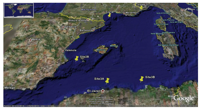
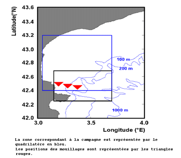
<p>The PRISME cruise objectives were to: - quantify the risk of earthquake-induced sedimentary liquefaction (for areas studied on the Algerian margin and slope off Nice, France); - quantify the risk of instability and failure due to loss of resistance in sensitive clay (slope off Nice); - quantify the risk of slope breaks and erosion caused by bottom currents (canyon heads - gulf of Lion); - identify the triggering factors for slides seen off Ibiza; - and begin to identify the turbidity related to seismic activity along the Algerian margin. This falls under the ANR-Isis an dGDR Marges projects. The cruise took place on 5 sites: Site 1A - Gulf of Lion - North: N 42° 50.00' South: N 42° 40.00' West: E 003° 35.00' East: E 004° 0.00' / Site 2B - Ibiza channel - North: N 38° 39.00' South: N 38° 37.50' West: E 000° 47.00' East: E 000° 51.00' / Site 3A - Alger - North: N 37° 30.00' South: N 36° 40.00' West: E 002° 00.00' East: E 004° 00.00' / Site 3B - Djijel North: N 37° 30.00' South: N 37° 00.00' West: E 005° 00.00' East: E 004° 00.00' / Site 4A - Djijel North: N 43° 40.00' South: N 43° 38.00' West: E 007° 12.00' East: E 007° 15.00'.</p>
-

<p>?The cruise took place from 22 November to 20 December 2006 aboard RV L'Atalante. Its objective was to study the formation of passive continental margins and a special sedimentary sequence which exists all over the Mediterranean. The result of national (IUEM Brest, Géosciences Azur, University of Lille, UPMC) and European (Universities of Lisbon and Bologna, GEOMAR and AWI) cooperation, directed by Ifremer, the cruise mobilized some twenty scientists for nearly one month. The related project is GDR Marges.</p>
-

Carry out surveys with Side Scan Sonar Sweeping in zonesProposals. They focus on the seabed research of Mediterranean sea (Spain ), both indirect and direct. Carry out a survey of the fishing beaches to later elaborate fishing charts. Systematic bathymetric survey of the study areas with 100% coating (Multi-beam echo sounder EM-300). seismic profiles according to the ship's defeat (Topas 710 system). Performance of sound velocity profiles in the water column. Side sweep sonar in selected areas. Sediment sampling (Shipeck dredges - Box corer). Sampling of Rocky Outcrops (Rock Dredge).
-

Analyze and evaluate the environmental impact on the coastal area of Gibraltar caused by the dumping of concrete and rock blocks into the sea.
-

Background and Aims MEDWAVES The Strait of Gibraltar (SG) and the surrounding areas, Gulf of Cadiz (GoC) in the Atlantic, and Alboran sea (AS) in the Mediterranean, are key areas to understand the distribution and connectivity of marine communities (Patarnello et al. 2007), as the SG and the encounter of water masses at the Almeria Oran front represent an oceanographic transition area, connecting the Atlantic Ocean and the Mediterranean Sea (Lacombe & Richez 1982). The Mediterranean water flows out from Gibraltar (MOW), extends towards the East of the Atlantic, building a warm and salty water mass which propagates in North West direction from Portugal originating the “Mediterranean Water“ (MW) in the Atlantic. This warm and salty water mass becomes characteristic of the North Atlantic in mid waters (around 1100 m) (Candela 2001). The occurrence of cold-water coral (CWC) communities in the NE Atlantic has been related to the pathway of the MOW, whereby this current system would have an historical influence on the migration of coral larvae and (re)colonization of the Atlantic in the post-glacial era (De Mol et al. 2005, Henry et al. 2014). The MEDWAVES (MEDiterranean out flow WAter and Vulnerable EcosystemS) cruise target areas under the potential influence of the MOW within the Mediterranean and Atlantic realms. These include seamounts where CWC have been reported but that are still poorly known, and which may act as essential “stepping stones” connecting fauna of seamounts in the Mediterranean with those of the continental shelf of Portugal, the Azores and the Mid-Atlantic Ridge. During MEDWAVES sampling will be conducted through two of the case studies of ATLAS: Case study 7 (Gulf of Cadiz-Strait of Gibraltar-Alboran Sea) and Case study 8 (Azores). The main goals of the cruise are: (1) to characterize physically and biogeochemically the MOW Path and understand its interaction with the general Atlantic Meridional Overturning Circulation (AMOC) stream, from the Alboran Sea to the Azores, through the Gulf of Cadiz, and the Ormonde Seamount (see map), exploring the relationship between the oceanographic settings of these target areas and the ecosystems therein (ATLAS WP1 and WP3) and (2) to characterize communities associated to the transition area, and sample for population genetic analysis aiming at understanding the way the populations located in the target areas contribute or have contributed to connectivity between the Mediterranean Sea and the Atlantic Ocean (ATLAS WP3 and WP4). Results gathered during the cruise will also contribute later to feed other ATLAS WPs. The activities planned to achieve these aims are presented in the brief description of the work program of the different research teams participating in ATLAS (Work program of the research teams).